

I've never been on a plane before, so this was a first; going through all the checks, complying to security restrictions, realizing that the overhead bins on Air Transat don't actually allocate sufficient space for each passenger despite enforcing a strict carry-on bag dimensions, popping ear drums, riding through turbulence, and arriving in some other land. This was all a first. Parents scored some deal with the travel agency so I have no idea who we're touching base with when we arrive at the Vancouver Airport, but I have been on tours before to know we should be looking out for someone with a sign.
Dad says we're meeting them just outside the #3 luggage pickup area. We get there. No one's there. But hang on, I see about 2-3 different Chinese groups huddled together nearby; it's got to be one of them. So I inquire the parents what our agency's name is (I didn't actually know at the time). "Uhh what's our agency's name again?" asks father. Oh shit. Are you serious? We just arrived to a place we don't know our way around, and you're not going to memorize our only point of contact's name? Those two groups I mentioned were not ours. Beside those two groups, there was a piece of paper folded several times so it could stand freely. A mother and daughter stood beside this. We unfold the paper and see the name printed was in fact the name of our agency. Wow. 8.5x11, Arial font. Could you guys not have invested a few more dollars to make proper signage? Why give yourself the extra effort of looking out for people you've never even met when you can use your company logo to make it easier for them to find you? Cheap-asses. Said mother had made contact with our guide. Because our flight was delayed, we didn't arrive to the meeting point as expected, so the dumbass guide who apparently can't read the Flight Status screen "went off to look for us". What an absolute mess in organization skills from this guy. Don't over-complicate things when you aren't updating the other parties. In any case, he eventually returns to this meeting point, and we move forward.
After boarding the shorty bus, I realized we're not actually in Vancouver, but rather in Richmond. I would figure we would be taken to our hotel rooms, but it is revealed at this point in foreign language (Dad's the translator) our hotel rooms aren't actually ready yet, so they're going to stall us out by giving us an improv tour around Vancouver. Really liking this agency's ability to get their shit aligned so far. The first place they take us is without a doubt Chinatown. While being larger and much more colourful than the one in Toronto, it's a heck of a lot sketchier with it being so close to the streets loaded with bums, and drug addicts. In said Chinatown, we're ushered to some dinky food court. "Have lunch, be back on the bus in 30 minutes" the guy said. Okay. Nothing exciting to report about here. The place is about as run down as certain plazas in Scarborough, Ontario.
We hop back on bus to be taken around the busy streets. Here we actually witness a bum in handcuffs for public smoking on the right, and a house for heroine addicts to "safely" stick needles in themselves on the left. You genuinely wouldn't feel safe to be in this area. This region is called Gastown by the way. Travel a few blocks outward, while still in Gastown, and now you're in the Financial district with upscale apparel stores. The atmosphere takes a 180 in a matter of crossing a few more intersections; quite an eye-opening moment. We stop by Canada Place, some building by the harbour just north of Gastown (unless we're still in Gastown). Tour buses are only allowed to stop for 3 minutes, but our tour guide gave us 5 minutes to do what tourists do; take photos, selfies, whatever. But his explanation of how he gets around that 3-minute rule and what his tourists should do if he's asked to move the bus just doesn't look good on the company whatsoever.
There wasn't much I was interested in capturing about Canada Place. It felt Dundas Square + Lake Shore for me; nothing outstanding. What was great however was that that round piece of land preserving all those trees called Stanley Park.

If there's one thing I've noticed, Vancouver and several BC places accommodate tourism via tour bus-designated parking spaces, something I haven't noticed much of for the GTA. These totems were located just a few steps from one of these tour bus parking spaces.


First failure of a tourist: Taking pictures of things and not bothering to read the information panel afterwards. Sorry, y'all.

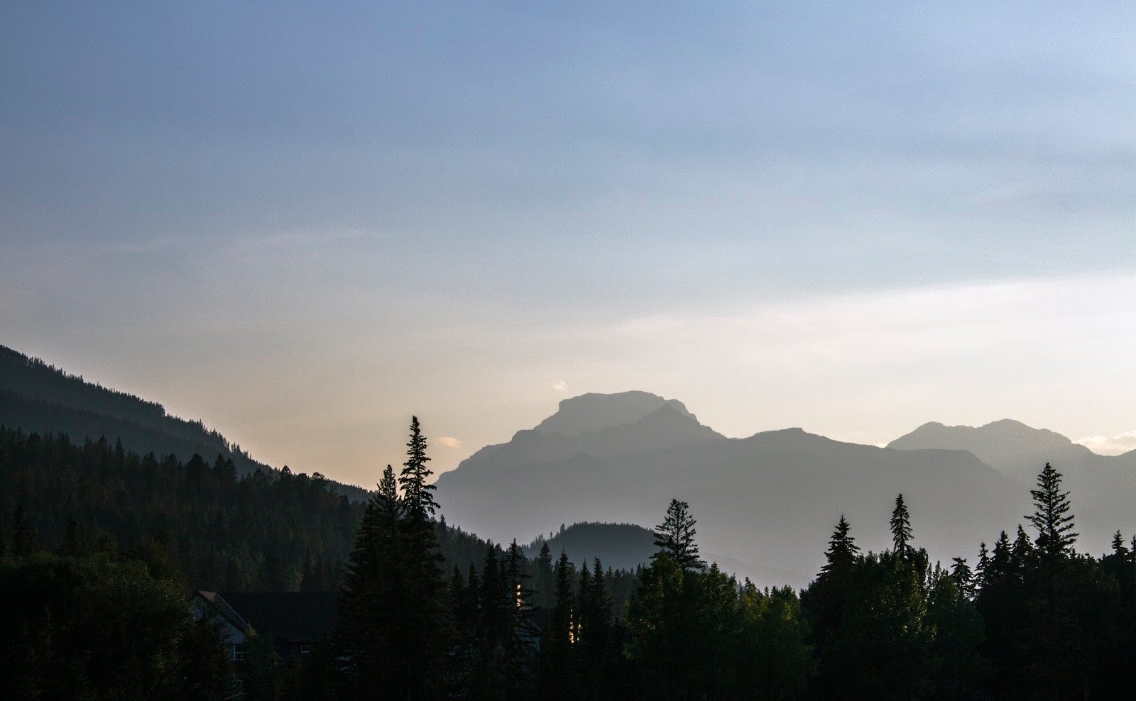
Still in Stanley park, I'm maximizing the 20 minutes we're allotted to capture the skyline of the Financial district on the edge of Stanley Park.

Trying my hand at Photoshop's Black & White for the first time.

The colours weren't exciting to look at here in the harbour but I did enjoy darkening the cargo lift arms.


There's that seawall. This just means these are one of those times of the year you can frolick with the rocks below.


Birds must be competing for a high-score on this board. Stalling is over. The hotel rooms are ready. The actual Rockies Tour has not begun. Saturday is really just the day for those coming from outside the province/country to arrive here a day in advance. So for the rest of the day is entirely our time.

The fear of not knowing where to go instilled in my parents, we don't venture too far away from the hotel for food. We settled on recommended Kirin Seafood Restaurant, upscale Chinese, upscale prices. No valid opinions on their foods. Their vegetable plates sucked. Shrimp was the only meat we got, and boiling shrimp is not an art we can evaluate a restaurant on. The shrimp's meat was hella firm though.
Sunday:
 The tour's outline goes like this. It starts on Sunday. They offer this tour for local residents as well as people coming from Toronto. Those in Toronto need to get on a Saturday plane and be ready to get on the bus Sunday morning. Before we hop on the bus that's devoting the whole day to travel as far east as possible, I'm seizing the opportunity to check out places the Improv bus ride didn't cover.

This is some condo that was about 2 blocks away from us, facing the south-fork of Fraser River.

Surprise catch. A crane on a glass pane!

Same morning in Richmond BC, heading back to the hotel before the tour bus arrives. Westminster Hwy, east of No.2 Road.

Interesting thing about this tour. The tour packages they set up with their clients gives them options at select hotels to stay at. This of course means the bus will be traveling to several locations in a few cities to pick up these groups. On top of that, they also picked up local Vancouver citizens! In total, the bus made about 5 stops before everyone was picked up. I just happened to snap this on the Sunday morning (through a tinted window) at one of these stops.

All the peeps have been picked up. We get on Hwy 1 and start venturing. I believe we are on the edge of leaving Chilliwhack at this point.

One of the first clear sightings of bumps on the earth, with bonus clouds.


Oooh more low clouds.

One of the first rest stop areas we parked at. This one was just exiting Chiliwack. It was the beginning of seeing some mountains.

Uhhhh low clouds.... or maybe smoke from the recent fires south-east of us. Either way, the endless view was breathtaking. Seriously though, this made the place look ominous.

Bumped up the contrast.

Now we're in a warfare setting.

And this is more like what it actually looked like.

Going to guess we're somewhere on the Okanagan Connector at this point. The bus has been climbing and descending in this area. Rolling down the hill doesn't give you a sense of speed because there's little points of reference to notice you're on a slope, but I noticed that the needle on the speedometer exceeded the gauge's limit of 130km/h the whole time, which explained why the driver kept braking and letting off rendering an uncomfortable ride.

We can't go 100% all the way to Banff in one day. We make about 2-4 stops until we decide to stop. They randomly took us to some winery; pee break, local business promotion. Apparently Grizzli had made a winning ice wine thanks to their geographic location. It's a lot sweeter than most red/white wine I've tried. But then again, there are about 5 other wineries in West Kelowna here, and Google reviews says 3.5/5, so take your grain of salt and do your thing.

This was a Chinese tour. Most Chinese speak Mandarin. About 3 other groups with us were the only ones who spoke Cantonese. Grizzli probably employed several Mandarin speakers solely to cater to entertaining First Travel Express and other Chinese tours from Vancouver. Otherwise, I wouldn't know where they'd be pulling in their income for their well-put together interior (no pic of that). While said employee rambles off about how great their products are, I'm outside at their vineyard.

Can't remember if I busted out the macro lens for this, but I'm lead to believe that is not the case.

Same-day pee break, Hwy 1 is a Trans-Canada Highway. Basically the road's only purpose is to connect cities with cities in other provinces. That said, there's practically nothing in between. So to accommodate those (i.e. truck drivers) who need places to stop for a moment, they step up these "rest stop areas" where people pull off the road to park their cars, take a washroom break, etc.. This one had a gift shop, which looked like a repurpose train station, as the highway was parallel to a set of tracks.

This is what the highway around this rest stop was like. All trees, single lanes with a passing lane every 20km or so, with only about 2km of road to pass any slowpokes.

This is still Hwy 1, despite looking like a regular street. Those cars in the distance are coming into the small city of Revelstoke. Hwy 1 cuts right through its middle.

We finished up dinner at some random Chinese place (seriously don't know why they exist in the middle of nowhere), and Revelstoke is the furthest we're traveling for the day. We did stop ioff at some random shop who sells their own locally grown fruits. I picked up a bottle of Boylan Grape (never seen this flavour at Big Smoke Burgers). Time is around 7pm or so.

Never being on a suspension bridge before, it was initially startling to learn that despite the sidewalk on the bridge is made of concrete, trailer trucks passing by cause the entire bridge to rumble. Mom swiftly got back on solid land. There's really not much to look at here in Revelstoke, at least in this area.
Monday:
The distance to Banff isn't much longer. We drive through a stretch of road that's considered an avalanche area. There is a rest stop with an educational facility that displays taxidermied wildlife in this area.


Just outside the facility, the sun has finally reached over the mountain that has shaded us this whole time. I actually cannot find this place on Google Maps.


Back on the road we go.


And......

Finally made it to Lake Louise, but holy moly are there a lot of people for a Monday.


Like all tours, you don't get a say in how long you want to stay at places. Soon after, we've been pulled to the other side of the highway and wnet up Whitehorn Mountain, where the Lake Louise Ski Resort resides. Took the Glacier Quad Express lift. Gave us a great view of all the mountains near the lake (the tiny wee ol' lake off to the right).


That's the lodge where we had another buffet lunch. Think we were given 2 hours to eat and go up/down the lifts. This is where I start having problems with some of the passengers and the tour guide.
1) The tour guide has taken no time to establish any form of communication with users should they go missing. Although there's no reception in this area (at least for me), it would've been nice to put some effort into this. 2) The people who speak/read insufficient English decide to board a trip to Canada and not know where to find a washroom. Hello? You didn't even come prepared to cover basic-level emergencies? UX Designers invest so much time into making signage that are user-friendly and overcome language barriers, and yet we still keep finding these people.


With the lake out of the way, we are slowly getting towards the resort town, but we've already entered Banff National Park at this point. Revelstoke to Banff is a shorter distance than Vancouver to Revelstoke. We arrive around 4 in the afternoon.

First place we're taken after dropping off our luggage at the second-cheapest hotel in this area, is the Falls View of Bows Falls, and the rest of Bows River.


After a quick 15-minute stop at Falls View, we're dropped off in the middle of Banff. Tour for the day was over, which meant free-reign until dawn. Screw mah peeps, I'm adventuring. This is Banff Avenue, north of Buffalo St.

A great view of Snow Peak (left), and Cascade Mountain (right).

Have another cliche B/W. No idea if I'm doing it "right", but I've been darkening foreground elements since it was easier to get the mountains to lighten up. It almost creates a pop-up effects between the two.

What's Banff like? Tourist city. Tourist to locals ratio is probably 15 to 1. Every gift shop here sells the exact same things... What's really neat is that there's only a 5% sales tax here. Score!

And despite this town's primary purpose is to support tourism, there are bus stops here. Just off the main street here are residential housing.

Right around the bend, leaving all the pretty buildings, shops and restaurants, we start moving back into the strip of hotels, the most luxurious being closest to all the attractions. It's amusing to see the quality of hotels decline as you continue walking north on Banff Avenue.


It's just after 7pm around this time.


The architecture and all the floral arrangements make this place quite lavish.

When you start moving away from the one glorified street, we start getting into tamer environments. The place is still quite open and clean nonetheless.

Found the Fire dept on Beaver St.

Looking east on Caribou St. The Tunnel Mountain trail is somewhere up there... or in there? There are trails in that area, but I never ventured that far. Google Maps doesn't have a name for this bump on the earth.

Interesting thing brought up by the tour guide about Banff. In order to make sure there is available space employees of these businesses here have a place to stay since they're in the middle of nowhere, there are government restrictions on who's allowed to live here. It means if you're retired, you're out! This also prevents anyone trying to purchase a their second home in this location.

Just an ordinary street. Still vastly different to cities and farm land in Ontario.

Direction of light worked out well on Chuck's Steakhouse.


South end of Banff Avenue, Bow River below, staring off at (what I believe is) Sulphur Mountain (left), and Eagle Mountain (everywhere else).

Following down the bridge over Bow River.
attempt #2 at same mountains.

Staring down the road to Banff National Park Administration Building.

If I ever wanted to live in a bubble of a civilization, this could be one of them.

I'm going to guess that's Mount Norquay that's hosting cliche sunset over the mountain.

After watching the sun tuck itself under Norquay, photos now don't look so dramatic. This is Patagonia and CIBC on Banff Avenue.

Moving onto the west-side of this town, this is Bear st. between Caribou st. and Wolf st.. Not all the shops here feature the wooden underpass and signage, but it is pretty though.

Same street, but the blocking off of parking space to make space for restaurant tables or street benches reminds me of Port Credit.

Wolf St. looking back into Banff Avenue. See that church?

Just about done looking at stuff. Heading back to the dinky hotel room.

But wait, gotta capture a photo of this hotel first. This one goes by the name of Moose. Fancy.
Tuesday:

"Vintage" filter from the phone. Kills the colours, but it brings out a different mood. This was captured Tuesday morning.

This almost looks like a painting.


Got to love seeing the sun rays burst through the edges.


Banff's done, that's like 66% of the main trip done already. It's Tuesday morning. We go back the way we came from, but we diverge onto Hwy 93 going north into Jasper National Park. Tour guide did a quick stop just off the highway, there are literally random plots of land with no plotted lines for people to pull off and observe view like this. The landscape is wide, but a basic crop-sensor can't capture all of this. There will be a pending panoramic photo coming up.
It may look cool that that there's a lot of rock, but a 2012 Google street-view of this shows a much greater view when there's snow.


This is Hwy 93. Nothing beside it but trees and water. If you got stranded here, you are screwed. Barren roads have been pictures I've been trying to capture. I had the opportunity to after this shot, but our driver saw where I was and promptly told me to come back over. Remember these people are Mandarin speakers, and I'm like 0.02% fluent, but I think he said something along the lines of "OMG NO! THE SPEED LIMIT IS WELL OVER 100, AND YOU'RE GOING TO GET RUN OVER BECAUSE YOU'RE NOT GOING TO SEE THEM COMING ON SUCH A BARREN ROAD. GET YOUR ASS OVER HERE!"..... Like I crossed the road thinking all is well with the world the moment I set foot on a car's designated lane.


Rest over, continue making our way to attraction #3, Columbia Icefield Discovery Centre.

The Crossing Resort, basically a complete package of a Rest Stop area.

Gift shop, convenience store, gas station, diner, "the facilities". This one has it all.


The road takes this extremely wide bend to transition up the mountain.


Finally arrived.... and so did the haze. To be fair though, when the sun shines brightly enough, like it did during Louise and Banff, the haze is less apparent. Sunlight too OP.

Some other plot of ice.

This facility is the Columbia Icefield Discovery Centre. It houses a gift shop (surprisingly selling the exact same merch as Banff shops did), as well as a buffet-style hip-looking restaurant called Altitude. Selection of foods was culturally diverse for a buffet outside of Ontario. One of the best places they took us to.


Before we actually head up to the glacier, we're having lunch first at Altitude, again on another tight time limit. Place is modern, feels cozy and the colour palette is bright.

Loaded my plate up at Altitude. quinoa, fried fish, spring mix, clam chowder, beef stew, some curry, pulled pork and more.


The Centre has a cool transit system where they arrange where the bus takes their guests. We got on the full-package, which would take us to the Athabasca Glacier and Glacier Skywalk (no glacier found there). The roads that take you into these locations are actually fenced off despite the open land. Hmmm. Once on the glacier, there are posts that indicate where we're not to traverse any further because the ice is all lop-sided, basically not the safest for dumb ol tourists to be walking on.


Tourists aside, this is the glacier where we are asked not to tread. There is water running around in this area, and the whole piece of ice is honestly not as big; just more evidence of global warming doing its work.


These are our ice walkers. The tour buses don't climb the ice. They stop partway up, and we switch over to these babies. They have no seatbelts, and can climb/descend from a 50-some degree slope on an insanely low gear.

That fog is a deterrent from appreciating the land up close.

Glacier excursion over, we get transferred directly to the Skywalk. More views of rocky lands. This walkway parallels the road we came from. Again, facility fenced off too. No glacier like I said. Think it's just part of making the name sound more alluring.

I'm no expert, but this definitely doesn't look like a glacier was through here.


This panorama came out awkward.

The view is not as colourful as some other places, but it is neat to see each mountain is composed of different rock types. At the bottom of this valley, there is this rapid stream. Thought it was cool.

Cliche tourist attraction. Something about a big crowd of people that makes the whole experience less authentic and immersive... I don't know if it's everyone pointing their cameras at uninteresting things or taking the exact same photos as everyone else beside each other.

Despite how high off the ground the glass pathway is, the tactile dots on the glass aids in taking away that fear of "walking on nothing". I've a fear of heights, fear of somehow falling/dropping something over the edge, but this bridge wasn't triggering this 100% of the time.... maybe it was all the goofy people cramming in there like an underground train.


By this point the trip is pretty much over and now we're doing another long bus ride back to our starting point, stopping halfway again in Revelstoke... unsurprisingly at the exact same hotel. What was surprising was that we stopped in Revelstoke's downtown area, where there was yet another random Chinese joint, buffet style. I must be spoiled on buffet restaurants in the GTA, because this place had the entire serving area about the size of one small dining table. I kept my meal a small one.
Wednesday:

Another rest stop. Don't remember where this was, but it's on the way back from Revelstoke to Vancouver. Today is the day to commute home.


Saved it for last. Capturing video through a window is not 5-star quality by any means, but I still wanted to capture what I could. A lot of shots taken while on a moving bus were deleted, so I've only kept 4 samples of different terrestrial regions. This is really the sort of experience I wanted to get out of going to the Rocky Mountains. Millions of trees passed, hundreds of mountains seen. This is what some of that in-between scenery looks like where you're in the middle of nowhere. To me, some of these sights were more breathtaking than the tourist attractions themselves. To a city folk, sights like these give you a different perspective of the world and (arguably) life.
Timestamps:
0:05 - Somewhere near Hope
1:30 - Towards Revelstoke
4:43 - Towards Jasper
5:39 - Leaving Jasper

All groups are dropped off back at where our meeting points were when we were picked up. It is Wednesday by this time. The Capilano trip is not until the next day, so we've got another day in Richmond, this time we venture southeast, because mah peeps just had to have Pho.

Richmond City Hall. Buildings here love using water as part of decorating their entrances.


In said Minoru Park, pathways are intricate and create closed loops. If cycling is your thing, this is a great place to do it... Actually, if baseball, soccer, basketball, shotputting, tennis and track & field are your thing, this park has all of that, and it is well maintained too.
This however is a photo of one of many spiders I found fishing for food on an Araucaria araucana, or Monkey Puzzle tree. I've never seen one of these strange looking plants before. From afar, they look like pine trees drawn by a 6 y.o.
Thursday:


Capilano Suspension Bridge. Place looked so great on some photos, when there is nobody on it. Honestly had this impression we were going to be up on some mountain on a very long bridge. Silly me dreamed a little too hard and should've anticipated another wave of tourists. Because of the volume of guests, you're told not to hold other people up. That means, the bridge is basically a 2-lane road with no shoulder. There is no place to stop, you're asked not to stop, so there's no real time for you take a moment to take in the scenery.... unless you find a dead day- this was a Thursday. Oh BTW, BC residents can visit this place all year round, free of charge, if they've been here before. Nice (if you live here).

The cliffwalk seen from the bridge. Excuse the unacceptable quality, but I cannot control the people walking on the bridge.

And this is what it looks like.... just walking in the same line behind someone else the whole time. Yay. I've a video of this:
Don't get me wrong. Still being able to trek bridges attached to trees was an experience of its own. The view is great, but there wasn't a view I could think of capturing in the form of a photograph up here I would consider beautiful. But maybe that's just me.
After being escorted from the treetop, we move onto the cliffwalk. This all feels like a chore being told where to go, without that option of being allowed to explore in X amount of time.

Bridge from the other side. Ironic when the vacation you take to get away from the urban setting is still loaded with people.